Big tourist circuit "Červený kámen" (Kopřivnice)
TYPE: walking trip

STARTING POINT
Trailhead - Kopřivnice, Train Station
Kopřivnice, Train station

FINISHING POINT
Štramberk, Train Station
ROUTE
STARTING POINT: Trailhead - Kopřivnice, Train Station (0 km) – (A) Janíkovo sedlo, Signpost – (B) Pod Červeným kamenem, Signpost – FINISHING POINT: Štramberk, Train Station (13,5 km)
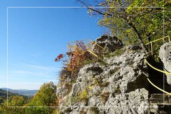
Kopřivnice, Train Station – Bezruč’s Lookout – Šostýn Castle – Raškův kámen (Raška Stone) – Janíkovo sedlo (Janík's saddle) – Červený kámen (Red Stone) – Štramberk, Train Station – Kopřivnice, Train Station
DESCRIPTION OF THE ROUTE
Along the Lachian nature trail route from the train station in Kopřivnice (A) to a train station in Štramberk (D) – the length of this route over the top of Červený kámen (Red Stone) is approximately 11,5 km.
The route can be shortened, so that you will not go along the nature trail from Janíkovo sedlo (Janík's saddle) (B) , but more to the right along the forest path (so called Circuit Way), that leads you after 700 meters to the slope (C) – Signpost Pod Červeným kamenem – and here you rejoin the Lachian nature trail route. Along it, you will walk to the train station in Štramberk (D) – route length without the top of Red Stone (Červený kámen) is about 8 km.
From there, you can return through the town to the trailhead (e.g., along the bicycle path around Kopřivnička, where you will meet with the nature trail again that leads you around The Bailiff’s House Museum - Fojtství Museum and the Church of St. Bartholomew to the train station (A) in Kopřivnice (ca. 2 km), or you can use the train.
INDIVIDUAL SECTIONS
(A) Kopřivnice, Train Station - (B) Janíkovo sedlo, Signpost
SIGN:

slightly demanding
 4,6 km
 188 m
188 m
 287 m
287 m
 127 m
127 m
SURFACE: forest path, forest road
(B) Janíkovo sedlo, Signpost - over the top of Červený kámen - (C) Pod Červeným kamenem, Signpost
SIGN:
moderately challenging
3 km
200 m
219 m
195 m
SURFACE: forest path, forest road
(B) Janíkovo sedlo, Signpost - (C) Pod Červeným kamenem, Signpost - without the top of Červený kámen
SIGN:

easy
630 m
27 m
10 m
35 m
SURFACE: forest road
(C) Pod Červeným kamenem, Signpost - (D) Štramberk, Train Station
SIGN:
easy
3,7 km
163 m
39 m
199 m
SURFACE: forest road, asphalt road
(D) Štramberk, Train Station - (A) Kopřivnice, Train Station - around Kopřivnička stream
SIGN:

easy
2 km
29 m
7 m
32 m
SURFACE: street, path for pedestrians and cyclists, footbridge over the tracks